And What it Can Tell Us
The 1838 Tithe map and Tithe Apportionment Book for Northam, Appledore & Westward Ho!
When researching family, property and community history we often turn to maps to show how things were. Early in the nineteenth century a series of maps covering the whole of England and Wales were produced and they can be used to find out who owned the land, who occupied it, what it was used for the size of the field and the rent payable. These maps were the Tithe Commutation Maps.
What were Tithes?
Tithes were a tax which had been in place since the Middle Ages where a tenth of all produce and profits of labour were paid to the Church. At first it was the intention that these tithes should pay for the upkeep of the clergy and to help to provide for the sick and the poor. After hundreds of years the tax had become separated from these good intentions and in 1836 an Act of Parliament was passed to reform the system and change it to a tax payment based on the prevailing price of corn, now mainly paid to private landlords, though church lands were exempt.
For modern researchers, the map of a local area together with the book called the Apportionment Book is invaluable.

- Fig 1 A section of the Northam Tithe map showing Diddywell from the Bideford and District Community Archive collection
The above section is from the Northam Map. All the fields are numbered. The roads are marked by shading. Using just the map we can check the field sizes and position and locate the roads and houses. Unfortunately the roads are not named.
If we put the map together with the Apportionment book the whole thing comes alive. Over the nearly 40 years that the Bideford and District Community Archive has been operating volunteers have contributed their efforts to transcribing the book from this:-
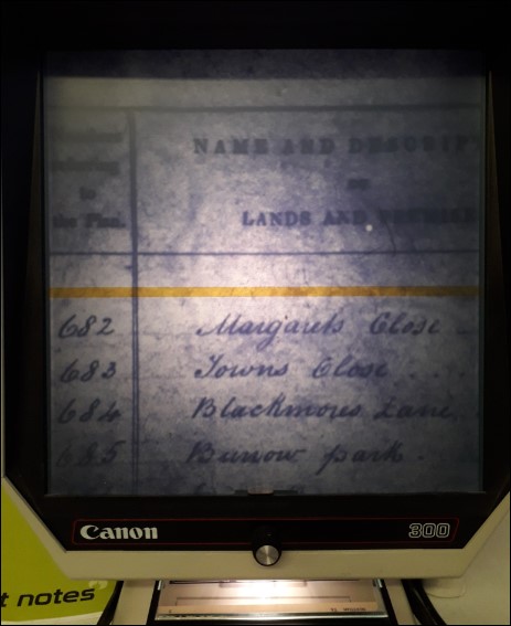
- Fig 2. A microfiche slide held in the Archive's collection which is a photograph of the original Apportionment book.The screen on this kind of viewer only shows a small section of each page d there are 6 pages per slide. This page shows field numbers and field names
To this:-
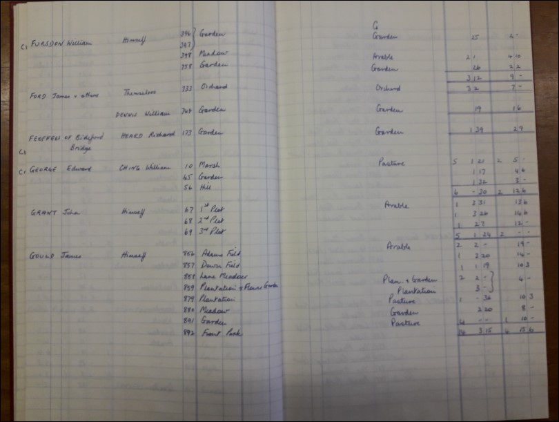
- Fig 3. A photograph of a book held in the Archive's collection which is a complete transcription of the microfiches of the local book. It shows the owner, the occupier, the field number, the field name, land use and area and payment due
To this:-
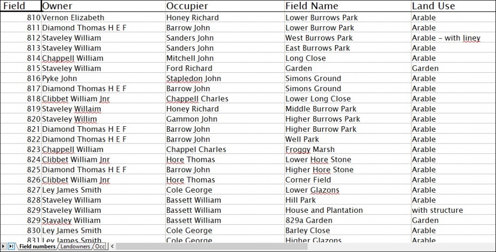
- Fig 4. A screen shot of a searchable interactive spreadsheet showing field numbers, owners, occupiers, field names and land use
Modern technology can really help enhance the usefulness of the Apportionment book. As can be seen in Fig 2 in using the original not only are we dealing with 19th century handwriting but entries are listed under the owners name. This was because the purpose of the 1836 Tithe Commutation Act was to reform taxation, therefore all the land owned by one person was listed together this means that the field numbers are out of order. To find a particular field necessitated a search through 14 microfiche slides until the number was found.
Fig 3. shows that earlier volunteers made this task much easier by copying the microfiche slides into a manageable book. This made the task of searching much easier but still time consuming.
The modern searchable spreadsheet produced by a current volunteer at the Archive Fig 4 now means that the field can be found in moments. The field number will lead us to the name of the land owner, the occupier the field name and how the land was used.
Recently this same volunteer has transferred the field names and land use onto a map pieced together from photographs of sections of the original map which had been produced by a previous local historian. The resulting map shown below gives a clear overview of land use in Northam Appledore and Westward Ho! in 1838,

- Fig 5. A section of the map showing field names and land use
Key to the map:
Pink = arable
Green = pasture
Yellow = garden or market garden (called a plantation in the book)
Orange = uncultivated furze and bracken
Blue = orchard
Brown = woodland
How to use the map and Apportionment book
Houses and Family Names
- Fig 6. A view of Appledore houses showing the plot numbers for their gardens. Using that number the occupier of the plot can be found
The map can be used to locate buildings and houses and who occupied them in 1838. For example the houses in the villages are all shown but the Tithe map records the gardens. By searching for an occupier's name or a plot number in the Apportionment Book it may be possible to identify a family name or locate the position of a house and thus gain an understanding of it's age. The census returns for 1841, 1851 and so on can then confirm occupation.
In a nutshell, if the house or road or field is on the map it was there in 1838 and of course for probably some time before.
Road and Track position and names
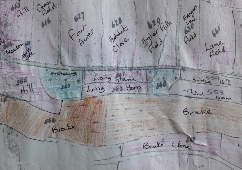
On the map the location of old roads and tracks can be identified but they are not named and so the field names from the book may sometimes indicate the name of the road. We have Jacket's Lane featuring in 5 field names to indicate the location of that lane. We have 2 fields in Northam called Windmill field and a Windmill hill in a different location. We have 10 fields called Ploddy at Bloody Corner. We have 2 fields called Sanctuary (Centuary) along Sanctuary Lane which is now called Bay View Road.
Westward Ho! has very little development in 1838. Underborough, Common, Venton and Youngerton Farms are shown.
- Fig 7. Showing a part of Westward Ho! along modern Atlantic Way
Hangers Lane Field runs alongside what was called Hangers Lane but this has now changed to Beach Road. However we have to use some judgement because that field also runs along modern Atlantic Way.
We can also see along the south side of what is now Atlantic Way, Orchards thriving on Westward Ho!s steep bank.
Some interesting historical features
When looking in detail at the map complete with field names sometimes interesting features emerge. Some examples are given below.
- Fig 8. House plots and gardens in Northam
Northam appears in the Domesday Book of 1086, and the rents were paid to St Stephen's Church Caen (in Normandy) on the instructions of King William. The layout of the house plots and gardens shows a clear medieval pattern with the houses fronting onto the streets and the long narrow garden plots lying behind them. The layout is not as neat as the previous Appledore pattern (Fig 6.) which probably shows that Northam's is much older.

- Fig 9. Shows Rope Path Field at the top of Irsha Street, Appledore and the black line above the field name shows the rope path running along behind the cottages
It is not unusual to find a rope loft or path in a seafaring town or village and this path here in Appledore was where lengths of fibres were laid out and twisted into ropes for ships.
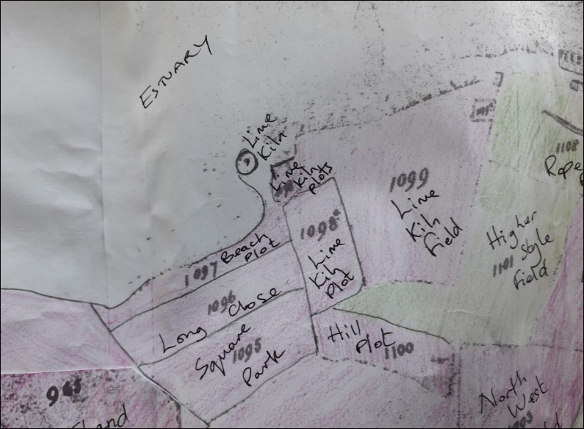
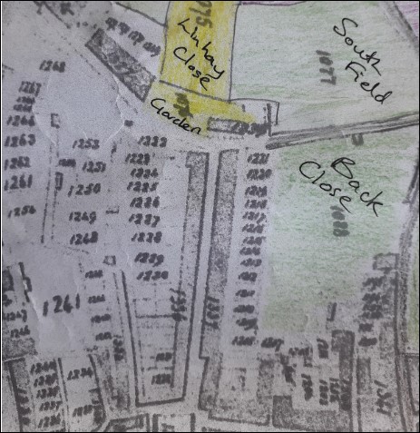
- Fig 10. 3 Fields with Limekiln in the name below the Rope Path at Appledore together with features showing a Lime Kiln
In the late 18th and 19th Centuries scientific discoveries led to increased production in farming. In the case of northern Devon the application of lime to arable fields was adopted by landowners and coastal lime kilns supplied by ships from Wales proliferated.
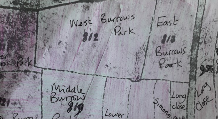
- Fig 11. Shows field 812 West Burrows Park
Today there is a Linhay – a local term for a small barn -in the south east corner of this field. Local knowledge identified this feature as a gun battery from the second world war. There are indeed features that appear to be shooting ports but the building has an older appearance overall. On referring to this map of 1838 although the building is not marked there is a clear indentation or detour in the hedge line indicating the presence of something.
Where to find the Map and Book
The whole map and the book and spreadsheet together with earlier versions are available at the offices of Bideford and District Community Archive, 1 Windmill Lane, Northam. An appointment can be made to come and use them or just to have a look. If required we will be happy to arrange for someone to talk you through how to find what you are looking for.
Email:
Kate Harrison July 2021