Why is the road named Windmill Lane?
When I first visited the community archive in Windmill Lane to see the archivist Mrs Pat Slade, this was the first question that I asked. It was also the request of my partner, who tolerates my interest in old things. Mrs Slade advised that the reason was that a windmill could be seen from the lane. The map of 1936 lodged at the archive indicates the position of the windmill and indeed the stump of the tower remain in situ north of Bidna Lane but is very difficult to see from the public highway. The current O. S map still indicates the remains of a windmill at Bidna.
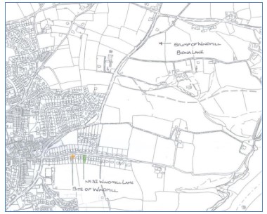
Figure 1- Map of Northam and Appledore parishes showing the location of the windmills
The fact the road is called Windmill Lane because of a view of a windmill seemed a little unlikely. The lane has always been shown as Windmill Lane on the O.S. Maps dating from 1932.
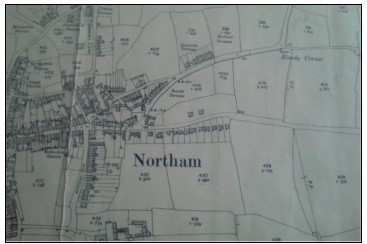
Figure 2- O.S extract from 1930 showing development on the site of the Windmill Lane windmill site.(NCA)
A visit to the North Devon Record (Barnstaple) proved very interesting. From reading the local history book Old Bideford and District (Goaman, 1968) I had assumed that the land which is now Windmill Lane belonged to the local large house known as Borough. The house although rebuilt in the 1800’s (Hoskins, 1972 edition) was until recently visible to the south of Windmill Lane. The record Office holds many references to Burrough House and the family that occupied it but also contained some indenture documents and a lease both of which had maps attached. The maps attached to the lease (NDRO) and indenture documents dated 1779 and 1857 respectively, clearly show that Windmill Lane was part of the Burrough estate and more importantly and unexpectedly, both maps had a line drawing of a Windmill fronting the lane.
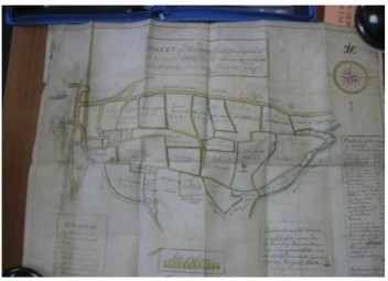
Figure 3- Overview of Survey Map of Burrough 1779 (NDRO 4087M/E12)
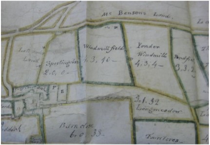
Figure 4-Closer view of above image showing the windmill
The key to the indenture map (Conveyance Burrough) indicates that the field on which the line drawing stands was named Windmill Field and the adjacent field, East Windmill Field.
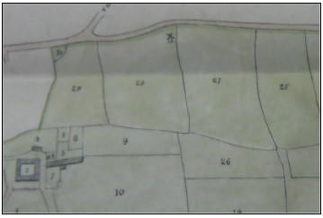
Figure 5-Extract from Conveyance of Burrough 1857 showing the windmill. (NDRO 4087M/T5)
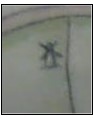
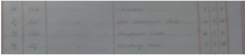
Figure 6- Part of the key relating to the above image showing the field names- windmill and east windmill field
To check further the tithe maps of 1843 (Tithe Map and Tithe Apportionment, 1843) were viewed together with the written description. The tithe maps are held at the Record office on microfiche and the copy quality is very poor. I reproduce my sketch made at the time.
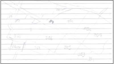
Figure 7- Poor quality field sketch of the tithe map field boundaries
The tithe apportionment record indicates that this the field numbered 386 and 385 was termed Windmill field and the adjacent East windmill field. The land was leased to Charles Partridge and the land owner was Maria Lopez Barton. The early map was not very accurate in terms of scale but is clear in relation to the layout of the lane. By using the historic maps and the 1932 edition O.S. map and comparing the field boundaries which have not altered greatly, it is possible to locate the position of the Windmill on the current road.
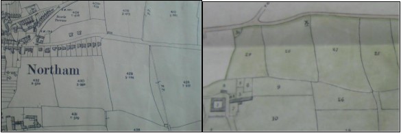
Figure 8- maps to allow the comparison of field boundaries
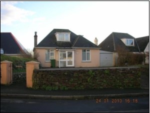
A bungalow now stands on the site now named tellingly, ‘Windmill’
The maps were shown to several residents on Windmill Lane and Mr and Mrs Sharrock from Number 20 Windmill Lane confirmed during a conversation in December 2009 that they had understood there was a Windmill along the road and that Mr Boon, the builder of the bungalows along the north of the lane had built himself a bungalow on the crest of the hill. During building works a millstone and evidence of the windmill were found on site. The resulting bungalow is named ‘The Windmill’.
At the time of the interview Mrs Sharrock reported that Mrs Boon had only recently been widowed and was unwell. Therefore this line of investigation has been abandoned for the time.
The issue of windmills in the area is clarified by the book Windmills of Devon by Walter Minchinton (Minchinton,1977). Minchinton identifies two windmills in the area; one in the parish of Appledore is visible from Windmill Lane. This windmill is marked on the OS map as ‘old windmill.’ This windmill is situated at Bidna Lane. The windmill was of stone construction and the stump still remains, although it not easily visible from the public highway. Minchinton relates that the windmill was advertised to let in March 1806. This indicates that the mill was obviously working at this time. In fact Minchinton's research goes on to state that “in June 1809 the Sherbourne Mercury said that the newly-built mill, which cost its proprietors upwards of £1000, was to let ‘on very reasonable terms for 7, 14, or 21 years’.” There are pictures from Minchinton’s book showing the Mill tower in 1919 before it was destroyed by a storm. These pictures were themselves reproduced from an article published in Devon and Cornwall Notes and Queries by R. Pearse-Chope (Chope, 1905).
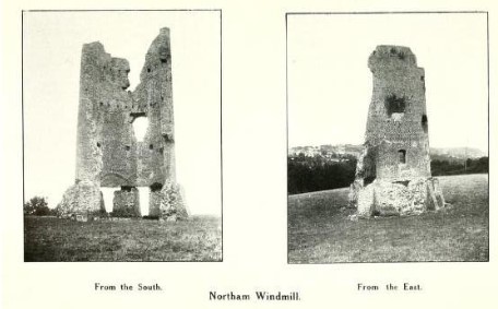
Figure 9- Copy of original illustration from W. Pearse- Chope's article on windmills of North Devon.(DCNQ)
The remains photographed in January 2010 are shown below.
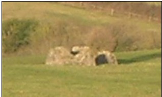
Figure 10- The remains of the Bidna windmill in January 2010
In addition Minchinton records in a section of his book termed ‘known windmills’ that there was a windmill at ‘Lane’, Northam. This windmill was left by Thomas Leigh, who died in 1609, to his wife Agnes’ ‘for life my dwelling house called “Borowe” and my windmill and tenement called Lane’ I consider that it would be a reasonable supposition that this is the windmill shown on the documents found that relate to the local manor at Burrough.
The reference to the name Leigh is also interesting in this context as this is a name known to be related to the house at Burrough. It is alleged to have been the inspiration for the character Amyas Leigh in Charles Kingsley’s book ‘Westward Ho!’ (Hoskins, 1972 edition).
The section in Minchinton’s book relating to the ‘Lane’ Windmill goes on to state that the foundations and millstone were found during building work in the late ‘60’s. According to the discussion with Mr and Mrs Sharrock the fact was reported that the mill stone was found during the building of the bungalow. The date of the construction of the bungalow would be earlier than the 1960’s as quoted in Minchinton’s book. The bungalow is shown on the OS map of 1930, and minutes of the Northam Urban District Council in 1930 record the granting of building consent for bungalows. It should not be ruled out that some later landscape gardening may have uncovered that millstone after the construction of the bungalow.
The information from Minchinton’s book would indicate that the windmill on Windmill Lane predated the existing windmill remains at Bidna. The deeds and indentures relating to the Burrough site would suggest that both mills were in existence at the same time in the early 1800’s although the rapid disappearance of the physical remains of the Windmill Lane windmill would suggest that it may have been redundant. This research has proved very interesting to the residents of Windmill Lane and will be added to when time allows.
References
N.C.A – O.S. Map Extract from 1932.edition. SS44294529
N.D.R.O - Ref:A/PB 12-14 (1843). Tithe Map and Tithe Apportionment 1843 N.D.R.O - 4087M/T5, N. (n.d.). Conveyance Burrough. 1857
N.D.R.O.-. Survey of Burrough-Property of Henry Downe Esq. 1779
N.D.R.O. – Ref: 4087 M/T5 – Conveyance of Burrough, the Cleave, The plantation and Boat Hyde.(1857)
Goaman, M. (1968). Old Bideford and District. Bristol: E. M. and A. G. Cox.
Hoskins, W. G. (1972 edition). Devon. Redwood for David and Charles.
Minchinton, W. (1977). Windmills of Devon. Exeter: Department of Economic History, University of Exeter,Exeter Industrial Archaeology Group
Pearce-Chope. W. – Windmill in Devon and Cornwall. Devon and Cornwall notes and queries 1903 volume 2 pages 226-7 http://www.archive.org/stream/devoncornwallnot111ame